Reserves
- Visit a Reserve
- Dawson Los Monos Canyon Reserve
- Elliott Chaparral Reserve
- Kendall Frost Reserve
- Scripps Coastal Reserve
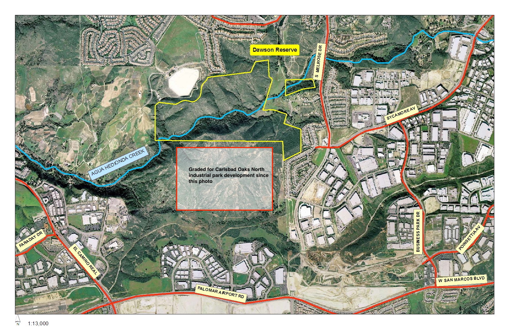
The Dawson-Los Monos Canyon Reserve occupies 235 acres 5.4 miles inland on the coastal plain of north San Diego County, surrounding the middle reach of the Agua Hedionda Creek where it flows through the Los Monos Canyon.
Named for the dominant landscape feature and Ida Belle Dawson, whose generosity and foresight led her to donate the land beginning in 1965, the Reserve was one of the founding sites of the NRS. Rapid urban development in the surrounding cities of Vista and Carlsbad since that time has made the ecologically diverse reserve even more important as a benchmark research site and an environmental education and outreach tool.
The land of north San Diego County was inhabited by native Americans for thousands of years from prehistoric times, with the Kumeyaay living in the watershed of the Agua Hedionda creek and lagoon and surrounding areas for hundreds of years prior to the arrival of the Spanish explorers. The name “Agua Hedionda” or “stinking water” apparently derives from the nickname given by the party of Governor Gaspar de Portola during a 1769 excursion during which they camped adjacent to the lagoon. The Europeans used the general area for grazing cattle, often with the cooperative labor of the native Americans.
Don Juan Maria Marron was a Spanish ship’s captain who arrived in San Diego in 1820. He became politically prominent and married the daughter of Juan Maria Osuna, the first alcalde of the Pueblo of San Diego. Rancho Agua Hedionda was granted to Marron by the governor of California, Pio Pico, in 1842. Its 13,311 acres extended from the coastline inland to the eastern boundary of the current Dawson-Los Monos Canyon Reserve, four miles north to the Buena Vista Creek, including the site of the still extant Marron adobe, and to the Quiotes Spring, site of the Matthew Kelly Adobe, re-built by Leo Carrillo, which still stands in the Carrillo Ranch development two miles south of the Reserve. Following Marron’s death in 1853, his family could not repay a $6000 loan from local banker Francis Hinton (for whom the southern peak of the Los Monos Canyon is named), and in 1865 Hinton assumed ownership of the ranch. When Hinton died with no heirs, the Ranch passed to Robert Kelly, a longtime associate and the ranch manager. Robert’s brother, Matthew, homesteaded the Quiotes Spring at his brother’s request, to keep out potential competitors for the land.
When Robert Kelly died with no offspring, he willed specific portions of the ranch to his nine nieces and nephews, including Mary Emma, who received 650 acres encompassing the area of the current reserve. She married Hamilton Monroe Squires (for whom the present adjacent reservoir is named) and in 1897 they built the home where Ida Belle was born in 1901, immediately adjacent to, and looking out over, the landscape of the current Reserve. Ida re-occupied the house following her marriage to Clarence Dawson and return to the ranch in 1944, until her death in 1996. That house was removed in 2008 due to termite damage and substandard utilities, and replaced with a new house in a similar style, now occupied by one of Ida’s daughters, Maud (“Betsy”) Shaffer. Ida’s other daughter, Madeleine (“Elaina”) Blankinship lives on a nearby parcel in the 1979 subdivision, as does a grandson, Jonathan Martin.
Beginning in 1965 and until her death, Ida donated land designated as permanent open space to the University of California with the intention of preserving some of the best remnants of the natural landscape of the Rancho. The surrounding lands became residential, commercial, and industrial developments, and public parks and facilities.
Geology
Underlying the area is quartz diorite of the Southern California batholith, rock that is heavily fractured and weathered near the surface. The Agua Hedionda Creek cut the Los Monos Canyon through this area of rolling hills, where Mount Marron and Mount Hinton flank the canyon at its deepest point, within the Dawson Reserve. Weathered granite boulders dot the upper slopes where the soils are thin and sandy. Remnant deposits from a coastal terrace cover part of the canyon’s western boundary. Soils along the canyon floor contain deep deposits of alluvium mixed with organic debris. Two dormant faults were identified just northwest of the reserve boundary prior to construction of nearby Squires Reservoir.
Climate and Hydrology
The characteristic Mediterranean climate of coastal California is modified in Los Monos Canyon by steep slopes that drain cool air from the hillsides down to the canyon below. Temperatures in the summer can vary as much as 15 degrees Fahrenheit between hot south-facing slopes and the cooler riparian woodland. Summers are typically dry with occasional thunderstorms. Most of the annual precipitation of 12 inches falls during winter and spring, while coastal fog provides additional moisture in May and June.
The middle reach of the Agua Hedionda creek flowing through the Reserve receives flows from approximately 10 square miles of the upper watershed, including the Buena Creek drainage. Within the Reserve, the main stem of the creek is joined by two small tributaries before flowing into Los Monos Canyon, where the outflow from the Squires reservoir also joins. The creek through the Reserve is presently perennial, with summer flows largely due to urban runoff, although historically it was sometimes intermittent, depending upon seismic activity that altered spring flows to the creek. (Dawson, pers. comm.) During low flows one finds the four regimes of typical coastal low-gradient streams: pool, glide, riffle, and run. Heavy rainfall, which may occur once or twice a decade when El Niño conditions prevail, raises the creek flow over its banks, flooding the adjacent meadows. Urban development over the last 30 years has caused significant changes in the watershed above the reserve, where impervious surfaces account for an average of 39% of the land area in the city of Vista. The resulting increased speed with which larger volumes of storm flows reach the creek has resulted in increased sediment transport, downcutting of the streambed — to the granite bedrock in places — and thereafter widening of the banks of the main creek and deepening of the tributaries.
After leaving the reserve the main Agua Hedionda is joined by La Mirada and Little Encinas creeks as it descends four miles through developing agricultural lands and a mobile home park before entering the upper reaches of the Agua Hedionda lagoon, which opens onto the Pacific Ocean in the city of Carlsbad.
Habitats and flora
The Reserve contains habitats defined by terrain, exposure, and land-use history, including at least 150 species of vascular plants. In the wide upper canyon, old pastures of introduced annual grasses and forbs intermixed with native herbaceous species are the result of a century of grazing; seasonal floodplain species such as curly dock, tarweed and vinegar weed are seen in wet years, and where grazing has been eliminated within the reserve, the meadows support the narcotic datura with its resplendent mauve flowers, bush lupines, expansive vines of pungent yellow-flowered coyote melon, and native bunch grasses.
The south facing slopes of Mount Hinton support elements of both inland and coastal sage scrub and chaparral with stands of chamise, laurel sumac, scrub oak, black and white sage, and succulent dudleyas. The north facing slopes of Mount Marron supports the more mesic chaparral characterized by blue lilac, chaparral currant, mission manzanita and monkeyflower shrubs. The abundance and composition of flowering annuals on these slopes varies with annual weather variations and the recency of fire. Species include white popcorn flowers, bright pink canchalagua, small yellow California poppy, three species of lupines, delicate pink spineflower, and golden yarrow. Where fire has not occurred for a century or more, slow-growing endemic lichens, the ultimate climax species, have been found growing on the towering specimens of mission manzanita, scrub oak, and lemonadeberry.
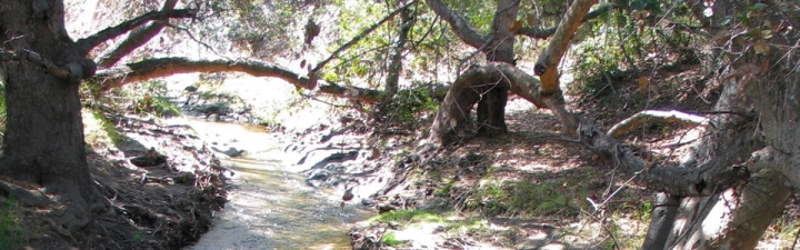
Along the creek through the reserve, mature California sycamores, coast live oaks, and large arroyo willows create a riparian forest, possibly the last good example in urbanized north coastal San Diego County. With increasing flows related to upstream urbanization, the arroyo willows and ash, characteristic of more dynamic stream regimes, are occupying the light gaps created by the loss of large oaks along the unstable stream banks. Lower in the canyon where moisture increases and soils are deeper, there are large bracken ferns, and the woodland understory blooms in spring with fuschia-flowered gooseberry, clambering virgin’s bower, wild rose, and an unusual double-flowered blackberry. Wildflowers at the woodland’s edge include cinquefoil, cream cups, and meadow rue, while wild celery and yerba mansa grow along the creek banks. Poison oak creates a formidable thicket at the reserves’ western edge.
Fauna
The varied landscape provides a network of habitats for animals to use for shelter and forage. A focused survey of the insect fauna has not been made, but there is clearly a large diversity. During spring, honey and native bees are conspicuous among the wildflowers, while butterflies perform mating dances along the ridge tops. Tarantulas hunt along the dry slopes, while weaver spiders ensnare flying insects and visitors in the riparian understory, scarab beetle species consume the woodland detritus, and native ants harvest seeds of meadow plants. Long-term surveys of aquatic invertebrates reveal healthy populations of water striders and pollution-tolerant midges, mayflies, and clams, but fewer larvae of more sensitive genera, such as dragonflies, caddisflies, and stoneflies.
The moist canyon floor harbors a variety of amphibians including the Pacific tree frog, garter snakes, and kingsnakes. In the creek, crayfish can be found year round. Along the drier slopes, western rattlesnakes, gopher snakes, and rosy boas hunt abundant birds and small mammals. Several lizards including whiptails and coast horned lizards can be found.
Over 75 species of birds can be found using the reserve’s micro-habitats and many breed in the woodland and forage in the chaparral. The riparian woodland provides nest sites at all levels from the canopy to the forest floor. Anna’s hummingbirds nest in the woodland understory and feed upon the nectar of chaparral monkeyflower and other blooms on the dry slopes. Cavities in the tree trunks attract hole-nesting species such as white-breasted nuthatches, tree swallows, acorn woodpeckers, and barn owls. Wrentits, towhees, roadrunners, and scrub jays nest largely in the chaparral.
Insectivores such as western wood pewees, ash-throated flycatchers, and black phoebes forage throughout the canyon. Six raptor species hunt and breed on the reserve, including black-shouldered kites and red-tailed hawks. Small mammals including voles, two species of woodrats, and the California ground squirrel provide a steady diet for raptors as well as for coyotes and bobcats. Recently (2013), deer have been seen in the reserve for the first time in three decades, suggesting that improvements to habitat connecting underpasses in the surrounding area are working, and that at some time we might once again have mountain lion on site.
The Dawson-Los Monos Canyon Reserve, formerly part of the Rancho Aqua Hedionda y Los Monos Spanish Land Grant (see history section) is now occupies lands within the boundaries of the cities of Vista and Carlsbad. Access to the reserve is possible from the east, in the city of Vista – see below. To visit the reserve, an application and reservation(s) must be submitted to the UCSD Natural Reserve System at least a month in advance.
Pedestrian access for day use to the lower reserve is via the Buena Vista Park, and to the upper reaches of Mount Hinton via White Birch Drive, both off Shawdowridge Drive, in Vista.
To the lower reserve, enter the Buena Vista Park and leave your vehicle(s) near the “duck pond”. Walk north along the short road across the dam, and turn left down the eucalyptus-lined dirt road, staying on the north fork (closest to the hillside.) The entrance gate to the reserve is in the fence on the right, just as the path veers left into a large meadow. The combination to the lock will be made available to permitted users. From there, a dirt path leads along inside the fence and makes a right angle at another fence line, then leads to paths up Mount Hinton (to the right) and down to the Agua Hedionda Creek, the headquarters trailer, Mount Marron, and the Los Monos Canyon (to the left.)
To access Mount Hinton, drive to the top of White Birch Drive and leave your vehicle(s) in the cul-de-sac. The entrance to the reserve is a gate in the fence, for which you will need the combination. Watch for honey bees as you cross the “Red apple” iceplant from the street to the gate. The short entry path joins the footpath from the valley (to the left) to Eagles’ Nest point (to the right.)
Vehicle access to the reserve itself is via Dawson Drive, and a dirt road during dry periods only, with use restricted to Reserve staff, and users with a need to transport research equipment and supplies to the headquarters trailer. Visitors granted this access will require an entry code for the electronic gate on Dawson Drive, and another code for the combination lock on the interior boundary gate.
There are often horses in the pasture through which the dirt road leads; please be very careful to close and lock all gates as you found them. Do not leave your vehicle unattended in the pasture; the horses may damage it.
The headquarters trailer/field station (see map), is equipped with line power for lights, heating, and equipment, solar hot water, gas for cooking, and internet access. A wireless LAN is available at the trailer, and is being extended across much of the reserve. There is a weather stations onsite, with data available at: https://dendra.science/orgs/ucnrs/status/dawson.