Reserves
- Visit a Reserve
- Dawson Los Monos Canyon Reserve
- Elliott Chaparral Reserve
- Kendall Frost Reserve
- Scripps Coastal Reserve
Kendall-Frost Mission Bay Marsh Reserve is situated on the Northern edge of Mission Bay in San Diego, California and occupies 16 acres of the 40 total acres of wetland habitat that includes the adjacent Northern Wildlife Preserve owned by the City of San Diego. Habitats include restored coastal sage scrub, south coastal salt marsh, tidal channels, salt flats, mudflats, sand spit, and eelgrass beds.
The Kendall-Frost Mission Bay Marsh Reserve protects approximately 21 acres of salt marsh and upland contiguous with the restored wetlands, mudflats, shoals, and open water of the Northern Wildlife Preserve owned by the City of San Diego. Together, these areas protect the last 40 acres of the approximately 2000 acres of emergent wetlands found in Mission Bay in the early 20th century. As early as 1942, students and faculty at the Scripps Institution of Oceanography (SIO) were using the Mission Bay marshes as educational and research sites. With the dramatic re-configuration of the Bay to create a recreational amenity following World War II, the value of the remaining marsh became evident, and in 1952 UC acquired parcels of the upper wetland from the Kendall and Frost families. The Reserve was incorporated into the Natural Lands and Waters Reserve System in 1965 as one of the inaugural sites, with research, teaching, and community outreach use of the site continuing to this day, and resulting in numerous doctoral dissertations, peer-reviewed papers, class field exercises, and public engagement events since. Recent graduate class projects supervised by Dr. Lisa Levin of SIO have addressed the critical issues of wetland restoration to expand the existing marsh, and the impacts of predicted sea level rise on the future ecology and management of the reserve. The urban setting of the reserve requires constant active management, but also presents many opportunities for educational outreach and community participation in environmental stewardship activities and hands-on science.
Prior to European incursion, Native Americans occupied at least three distinct villages in the areas surrounding the present-day Mission Bay, harvesting the abundant resources of the wetlands and uplands. While “Bahia Falsa” was navigable at the time of Spanish exploration in the late 18th century, land use changes, especially cattle grazing, brought by the Spanish and American colonists caused significant sedimentation. The San Diego River carried this sediment into both the San Diego Bay and Mission Bay, and in 1852 the US Army Corps of Engineers began the construction of a dike to divert the flows entirely into the latter in order to protect the former as the primary port. Continued sediment deposits by the San Diego River in the southeast corner of Mission Bay created large sandbars and mudflats. Starting in 1929 Mission Bay was envisioned as a recreational park, but it wasn’t until after World War II that those plans began to be implemented in earnest. The San Diego River was channelized to bypass Mission Bay by the ACOE in 1956, leaving only Rose and Tecolote Creeks as the tributaries. Continued dredging through 1961 created islands, peninsulas, and deeper water to facilitate recreation and boating. Before 1920 large floods and additional diversions had straightened Rose Creek in the northeast corner of the Bay, severing it from the main outlet channel flowing through the heart of the small delta marsh, and depriving the wetlands of its main source of fresh water, nutrients, and sediment. The remaining wetlands continue to be tidal, with the high tides covering half to the entire marsh, depending upon the particular tide and weather. Water quality is affected not only by boat fuel and flotsam from the bay, but also by urban storm runoff. Low flows resulting from initial storm flows, sewer failures and surface spills are intercepted in wells immediately upstream of the Reserve and diverted into the sewer system. Larger storm and accidental water main flows enter the marsh overland and via three storm drains. Geomorphology
Coastal terraces dominate the San Diego landscape. The La Jolla Terrace rises between 50 and 70 feet above sea level, cut by Mission Bay. The bay is filled with fine-grain alluvial deposits from the San Diego River and washed from upstream terraces. Filling of the mudflats and saltpans with dredge materials from the bay created uplands surrounding the emergent wetlands, and created areas for residential development, camping, and a mobile home park. Sand imported to create beaches in Mission Bay Park along the east side of Crown Point, southwest of the reserve, has shifted eastward and infiltrated the substrate west of the main channel, altering the porosity and subsurface habitat. In protected reaches of the eastern marsh, the substrate comprises finer silts and clays.
Habitats and Flora
The pattern of communities follows a classic vertical zonation of habitats from high marsh to submerged shoreline, determined primarily by the duration and depth of tidal inundation. Eelgrass beds, occurring as deep as six feet below mean lower low water (MLLW), are continuously submerged. Mudflats, with their rich communities of microscopic and macroscopic algae, diatoms, and invertebrates, are found at a median elevation of 131 cm above MLLW, and are exposed only at the lowest tides. Algae and bacterial mats also colonize the stems of marsh plants most of the year, contributing to the high productivity of the wetland. Upright herbaceous plants mark the beginning of the salt marsh at about mean sea level (96 cm above MLLW). Cordgrass characterizes the lower marsh (up to 162 cm MLLW), and occurs over more than half the marsh, with annual and perennial succulent pickleweeds interspersed. Higher up, at elevations from 108-174 cm MLLW, a more diverse perennial plant community also includes saltwort, saltmarsh daisy, and sea lavender. The highest community, covering almost one-quarter of the marsh area from 155-219 cm MLLW receives only occasional inundation, and is characterized by the rambling succulent sea-blite, and includes saltgrass, arrowgrass, saltbush, and marsh-heather. An unvegetated hypersaline salt panne occurs in the northeastern part of the marsh with elevations ranging from 143-227 cm above MLLW.
Approximately one acre of upland consisting of dredge material to a height of approximately 10 feet above sea level includes the site of the Reserve field station trailer, with a small laboratory, classroom, office, and overnight living quarters. The terrestrial and marsh-to-upland transition habitats, formerly dominated by non-native Eurasian annuals, several species of South African iceplant, and Australian eucalyptus and acacia, are gradually being restored with the introduction of native coastal sage scrub perennials and by specific management to remove non-natives and to encourage annual native plants through student and community projects. Removal by students and community volunteers of over 50,000 non-native grey mangroves from the marsh, introduced as part of an experiment in the mid-1960s, restored the substrate sufficiently to support native vegetation essential for resident endangered avian species.
Fauna
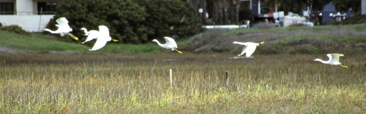
Mission Bay is an important stopover for thousands of birds migrating along the Pacific Flyway, with an almost continuous flow of different species visiting the marsh throughout the year. During winter, waterbirds gather in great concentrations on the waters at the lower edge of the reserve to rest and to feed, including large numbers of Western and ring-billed gulls, Bufflehead, Coot, Northern shoveler, Scaup, Northern pintail, and Brant. Several species of terns, including Black Skimmers, Caspian terns, elegant terns, and royal terns are summer visitors. Several hundred Forster’s terns build nests and raise their young each Summer on the floating rafts of vegetation and debris that lodge along the lower edge of the cordgrass meadow. State-listed California least terns forage in the marsh channels for small fish to feed their young in nearby nests on sandy beach areas, and California brown pelicans feed in the channels and nearby open water. Two other endangered species depend entirely on the marsh: Light-footed clapper rails build floating nests woven into cordgrass; however, with the decline of the population throughout its limited range (north to Santa Barbara), and inadequate stands of sufficiently robust cordgrass in this and other reserves, the U.S. Fish and Wildlife Service launched a recovery plan in 1987 which includes artificial nesting platforms in the Kendall-Frost marsh and elsewhere. These platforms are heavily used, and contribute significantly to the survival of the population, the most recent estimate being at least seven pairs, based on call counts and nesting activity. The rails’ preferred prey are the abundant lined shore crabs and California horned snails. Belding’s savannah sparrows construct nests among the dense perennial pickleweed and feed on seeds and abundant insects throughout the wetland.
Within the mudflats and channels there are dense populations of annelid, oligochaete, and polychaete worms, providing abundant food for probing birds, especially willets, marbled godwits, dowitchers, curlews, and whimbrels. Hornsnails graze along the algal mats, carrying with them the larvae of parasitic flukes that can infect shorebirds, fiddler crabs, and fish. Fiddler crabs are especially wary in this wetland, but their abundant burrows are evidence of their significance in the dynamics of the wetland food web. Yellow shore crabs burrow easily in soft mud and lined shore crabs, which do not burrow, expand their holes to accommodate their larger size.
The marsh’s tidal creeks and smaller channels provide habitat for many species of fish, including topsmelt, staghorn sculpin, and several species of rays. California killifish live in hypersaline pools, longjaw mudsuckers prey on yellow crabs and use their burrows when newly hatched, and arrow gobies live in mudflat holes with commensal hosts. Young halibut seek refuge in the marsh before making their way to the open ocean.
Osprey frequent the marsh, taking large fish, including mullet, while other raptors, including kestrels, marsh- and red-tailed hawks, and peregrine falcon prey on smaller birds, mammals, and reptiles. Reptiles, including gopher snakes and fence lizards, are present in the uplands, together with pocket gophers. Native raccoons and skunks, non-native opossums, brown- and Norwegian-rats, and feral and domestic cats hunt and forage along the edges of the marsh, and can have a significant impact on the nesting marsh birds, particularly the eggs and chicks of clapper rails. It is hoped that future habitat expansion will restore wildlife corridors to inland areas, providing access for coyotes, which are key to controlling these populations of mesopredators and thus increasing the survival rates of vulnerable low-nesting birds.
The Kendall-Frost Marsh is ideal for bird watching, even without entering the Reserve. The best overview of the marsh is from Crown Point Drive, where there are two viewing platforms, near Honeycutt and Lamont Streets. From here, many resident and migratory species can be seen.
The Kendall-Frost Marsh Reserve is protected by chain link fencing along its upper boundary with city streets, and by the property owners’ fence along its boundary with the Crown Point Villas. The lower boundary with the city of San Diego’s Northern Wildlife Preserve is not marked, as the contiguous wetland (40 acres) is managed as a whole, with the UC Natural Reserve System coordinating research and teaching use, and the city Parks and Recreation responsible for law enforcement. To visit the reserve, an application and reservation(s) must be submitted to the UCSD Natural Reserve System at least a month in advance.
The headquarters trailer is located at 2055 Pacific Beach Drive (corner with Crown Point Drive), and comprises a laboratory/kitchen, restroom with hot shower, office, and bedroom with double bed. It can sleep a maximum of six, but normal occupancy (with bed and cot) is two. There is electric light and heating, but no air conditioning. There is an internet connection, with wireless LAN; let us know if you will require access, and we will provide a password.
There is no vehicular access past the headquarters trailer area. Official vehicles and those of overnight users may park inside the fence if space allows; otherwise, parking is on the adjacent streets (observe posted street sweeping signs!)
Access for approved researchers and classes is possible from the headquarters trailer site, or a gate near Crown Point Drive and Honeycutt St.
When making your reservation, please specify your preferred access route and the areas of the marsh you wish to visit. Please note that during the breeding and nesting season for the marsh’s endangered avian species, there is only limited access permitted past the periphery of the wetland. Please provide verbal and mapped descriptions of the areas you wish to use. Researchers deploying markers or instruments are required to submit GPS coordinates accurate to within 3 m/10 feet.
Orange vests must be worn by marsh visitors: once your visit is approved, please arrange to obtain vests for each researcher and for each sub-group leader or teaching assistant or chaperone if your group will be split up.
Rubber boots are available for day use – once your reservation is approved, you may arrange to use them. If you bring your own boots, you must sterilize them with bleach before entering the marsh. Let us know if you need to use our bleaching setup.
For solo researchers, we recommend using our “marsh walkers” if you will be working in the muddier areas. Please inquire about renting them.
Please check the tides if you will be working in the intertidal zone.
Ryan Hechinger, Alejandra Jaramillo
The trematode parasite Euhaplorchis californiensis is commonly found in estuaries in California and Baja, including the Kendall Frost Mission Bay NRS. This parasite has a three-host life cycle (the horn snail Cerithideopsis californica, the California killifish Fundulus parvipinnis, and marsh birds). During the life stage found in the F. parvipinnis, E. californiensis encysts on the brain, causing changes in neurochemistry in the host that result in an increased frequency of conspicuous behaviors that make them 10-30 times easier to catch than uninfected fish. This phenomenon is advantageous to the parasite because it facilitates transmission to the parasite's final host, marsh birds, where the parasite sexually reproduces. The goal of this project is to better understand how infection status influences survivorship in a real-world environment.
Drew Talley, Katie Blaha-Robinson
Increased urbanization and habitat alteration have led to a steep decline in wetland acreage worldwide and particularly, in southern California. Pacific coast wetlands serve as vital habitats for migratory bird species, endangered and threatened species, nutrient regulation, water quality maintenance, buffering wave energy, and transferring carbon. Restoration efforts to mitigate wetland loss have a substantial impact on the total area of available habitat, but it is necessary to assess the short and long-term development of restored sites to ensure that the quality of ecosystem function is equivalent to natural habitats. The California killifish, Fundulus parvipinnis, is ubiquitous in wetlands within its geographic range, often the most abundant fish within southern California marshes. Understanding the spawning habits and reproductive history of this species will provide essential ecological information. Furthermore, this information can be used for introducing and monitoring F.parvipinnis populations in created and restored salt marsh habitats.
Janet Walker
Changes in climate, particularly increases in the frequency and intensity of extremes, are predicted to continue to dramatically alter ecosystems (IPCC 2007). Such impacts may be particularly profound in salt marshes that play a disproportionately large role in global carbon cycles (Mcleod et al. 2011). However, we often lack an appreciation for the mechanisms that underlie climate-driven shifts in community structure and ecosystem function. This paucity of information severely limits our ability to manage and conserve our natural resources in the face of global change. Unfortunately, studying climate change on natural ecosystems is challenging given the difficulty of creating realistic climates in the lab, and the expense of conducting long-term experiments in the field that capture major climatic events. Here, we propose a collaborative project that uses the current El Niño as a tool to better understand the impact of climate change on salt marsh community structure and function.
Brief overview of the reserve